|
|
|
|
|
|
|
|
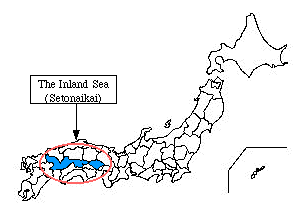
"Japanese SETO-NAIKAI, the body of water lying between the Japanese islands of Honshu, Shikoku, and Kyushu. It is composed of five distinct basins linked together by channels. Its east-west length is about 270 miles (440 km), and its waters are easily navigable. The sea has an irregular coastline and is dotted with hundreds of small islands, the largest of which is Awaji Island in the east. Entrance to the Inland Sea from the Philippine Sea and the Pacific Ocean is afforded by the Bungo Strait and the Kii Strait. The narrow Shimonoseki Strait at the western end leads to the East China Sea. The Inland Sea is a major transportation route between the Asian continent and Kyushu's Kansai area. Industries along the sea flourish together with trading and fishing ports and the commercial centre of Osaka-Kobe. The shores of the Inland Sea were Japan's leading salt-producing region until industrialization was given priority after World War II. The salt fields are no longer used, but a petrochemical industry is flourishing. Popular among vacationers for its scenery, the entire Inland Sea region is included in the Inland Sea National Park. "
Copyright © 1994-1998
Encyclopľdia Britannica, Inc.
|LOCATION| HISTORY | LIFE | FISHERY &
CITRUS FARMING | MY
FATHER | ABOUT
MYSELF |